Garin to Pleasanton Ridge: A New Trailhead on Palomares Road
East Bay Parks filed in September to open a trailhead on Palomares Road and link Garin toward Pleasanton Ridge. Here is what the half mile actually buys, what it does not, and how to comment before October 13.
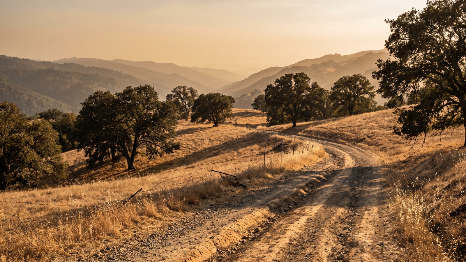
A dirt ranch road curving through golden oak-studded hills in Palomares Canyon above Castro Valley at golden hour. Photo: Houseberry
The question I keep getting about this one, from people who already hike Garin most weekends, is whether they will finally be able to walk from Hayward across to Pleasanton Ridge. The honest answer is no. Not from this project, and not soon.
What the East Bay Regional Park District actually filed on September 15 is smaller than that and more useful than it sounds: about half a mile of new trail, a public trailhead on Palomares Road where none exists today, and walking access to 955 acres the district has owned since 2011 and kept closed. Public comments close October 13, 2026. Nobody has written about it, and it is the closest thing to a new front door these hills have been offered in a while.
Half a mile of trail, and somewhere to leave the car
The trailhead is the real news here, not the trail.
The district bought the Chouinard property, 10 acres at 33853 Palomares Road, in 2020. It had been a winery. The buildings come down, a public trailhead and staging area goes in, and roughly half a mile of new multi-use trail runs from there into the existing Garin and Dry Creek Pioneer network.
Those two parks run to more than 5,800 acres and 35 miles of trails, and almost everyone walks in from the end of Garin Avenue in Hayward. The canyon side of that ridge has no public entrance at all. Half a mile is a twelve-minute walk and nobody's idea of a hike. As plumbing, it is the whole project.
Palomares Canyon is closer than it looks and harder to reach
Palomares Road is a two-lane canyon road that leaves Castro Valley near Dublin Canyon Road and drops southeast to Niles Canyon Road near Sunol. No shoulder, blind curves, a favorite with road cyclists, and shut by slides often enough that the county tracks it.
The site sits roughly midway down, about 5.5 straight-line miles from Union City's civic center, 6.9 from Hayward City Hall and 7.9 from Castro Valley Boulevard and Redwood Road. By car it is a good deal farther, because you drive around these hills rather than through them.
Here is the part to be careful with. The filing creates public access along selected existing ranch roads on the Owen property, the 955-acre former ranch across Palomares Road that the district's own project page says holds over eight miles of interior roads. That is ground the public has not walked in fifteen years. It is not a signed, continuous route from Garin's gate to Pleasanton Ridge, and the filing never claims to be. A separate district project is pushing the Bay Area Ridge Trail from Garin south to Niles Canyon. This one opens the middle.
What our scores already say about this corridor
These hills already rate well on open space, which is why I read this as an addition and not a rescue.
Palomares Rd, the mostly rural Union City neighborhood that shares the road's name, scores 4.5 out of 5 on our Public Spaces measure. That is the highest of any neighborhood we rate in either city. Fairview, up in the hills east of Hayward, sits at 4.0, as do Hayward Highland and unincorporated Castro Valley.
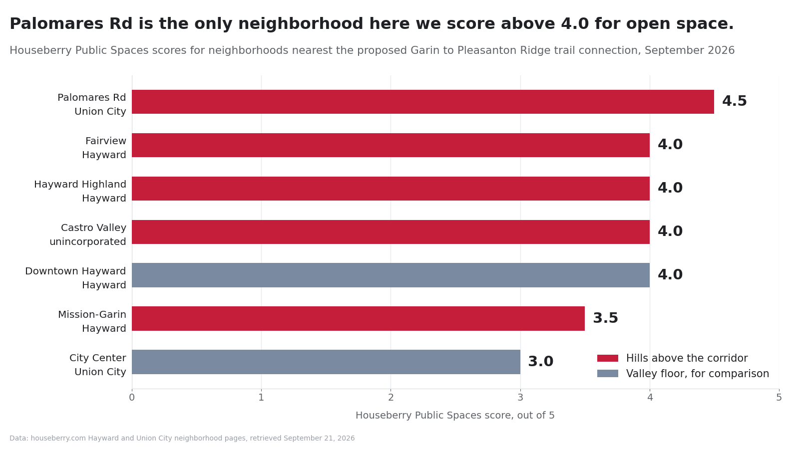
Run those same neighborhoods against our Amenities score and the actual trade shows up.
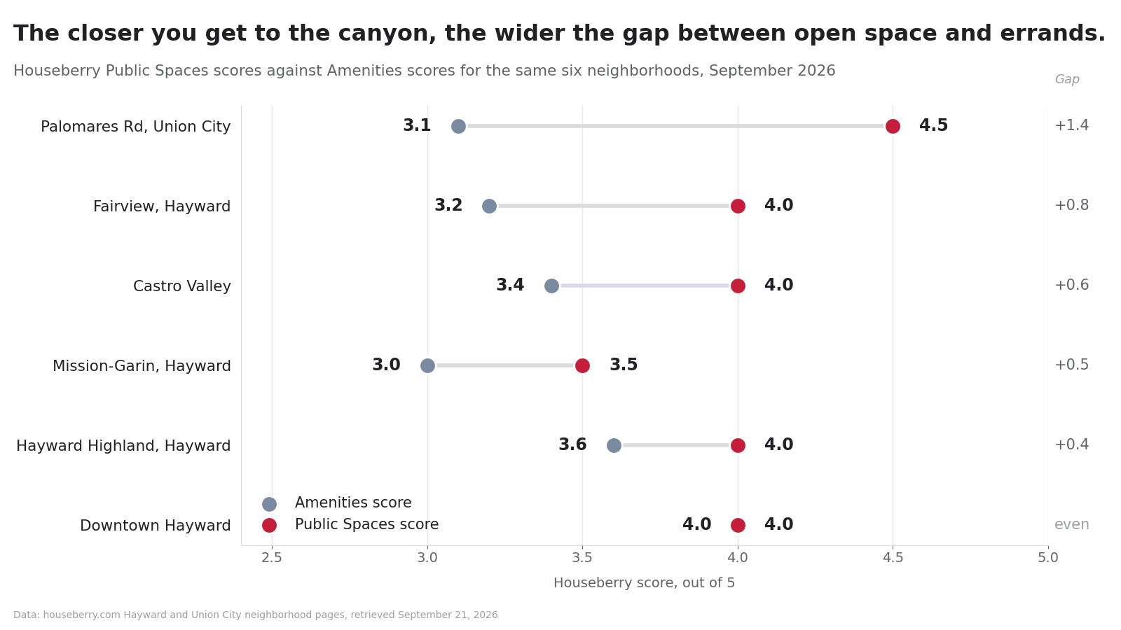
Palomares Rd is 4.5 on open space and 3.1 on amenities. Downtown Hayward, six miles down the hill, comes out even at 4.0 and 4.0. That spread is the hillside bargain in numbers. You buy trail access and a view by giving up the ten-minute grocery run, which is fine as long as you chose it rather than discovered it in month three.
Fairview's median sale price was about $902,000 in August 2026 and Palomares Rd's about $1.39 million, against a Hayward citywide median near $935,000 in July 2026. Hill markets up here are thin, so read any single month as a data point rather than a trend.
The at-grade crossing is the part worth reading closely
One line in the project description is doing more work than all the rest of it: an at-grade pedestrian crossing of Palomares Road.
People will park on one side and walk across to the other. On a canyon road with no shoulder, sight lines shaped by the hillside, and a steady weekend load of cyclists coming downhill fast. I want this built. I also think that crossing is the single thing most worth writing a comment about before the 13th.
Two more belong in the same paragraph. A new staging area puts cars where there are none today, and a canyon road has nowhere to absorb the overflow on the first warm Saturday in March. And four crossings of seasonal tributaries in the Stonybrook Creek watershed, which drains to Alameda Creek, means streambed work that four state and federal agencies weigh in on, the Army Corps among them. The filing concludes those impacts come down to less than significant with mitigation. That is a finding, and the review window exists so people can test it.
How to think about a trail that does not exist yet
None of this is approved.
Comments go to Kim Thai, principal planner, at the district's Oakland office by 5 p.m. on October 13, 2026. The board is scheduled to take it up on December 15. If it clears, construction runs about four months in one dry season, so the earliest realistic public use is 2027.
Which is the right frame for what a filing like this does to a house. A proposed trailhead is not a reason to pay more for anything. A built trailhead with real parking is. We learned that the plain way when the Skyline watershed trail opened on the Peninsula and the binding constraint turned out to be 29 parking spaces rather than the permit everyone worried about. This filing does not say how many cars the Chouinard staging area will hold, and that number will shape daily life up here more than the half mile of trail will.
So if you are shopping Fairview or the Castro Valley hills this fall, treat it the way we treat any amenity: as something to research, not something to price in. Our Hayward neighborhood rankings already reflect what is open today. Put October 13 in the calendar, read the crossing section, and let the trail earn its way into the score once it is actually there.
Sources
CEQAnet, Garin to Pleasanton Ridge Public Access Project, Mitigated Negative Declaration, SCH 2026090573, East Bay Regional Park District, received September 15, 2026
East Bay Regional Park District, Notice of Intent to Adopt a Mitigated Negative Declaration, public review September 14 to October 13, 2026
East Bay Regional Park District, Garin-to-Pleasanton Ridge Regional Trail Public Access Project page
East Bay Regional Park District, Garin/Dry Creek Pioneer Regional Parks
East Bay Regional Park District, Bay Area Ridge Trail: Garin Regional Park to Niles Canyon
Houseberry, Hayward and Union City neighborhood pages and Hayward city guide, retrieved September 21, 2026
Map of Hayward Neighborhoods
Loading map...
View Full Map
Top Neighborhoods in Hayward, CA



All information provided on this website including but not limited to - school ratings, safety, amenities, user opinions, and property data - is for general informational purposes only. We do not guarantee its reliability, accuracy, or completeness. Users should independently verify information and consult appropriate professionals as needed. By using this website, you agree Houseberry is not responsible for actions, decisions, or consequences arising from reliance on the information provided
houseberry.com - CA DRE# 01847391
 Bay East ©2025. CCAR ©2025. bridgeMLS ©2025. Information Deemed Reliable But Not Guaranteed. This information is being provided by the Bay East MLS, or CCAR MLS, or bridgeMLS. The listings presented here may or may not be listed by the Broker/Agent operating this website. This information is intended for the personal use of consumers and may not be used for any purpose other than to identify prospective properties consumers may be interested in purchasing. Data last updated at September 21, 2026 12:00 AM