Santa Clara Station Area Plan: 8,300 Homes by Caltrain
Santa Clara's environmental filing for its Caltrain station area studies up to 8,300 homes on 244 acres. Here is what is proposed, how tall it could get, what it means for the Old Quad and South 101, and when the Draft EIR could land.

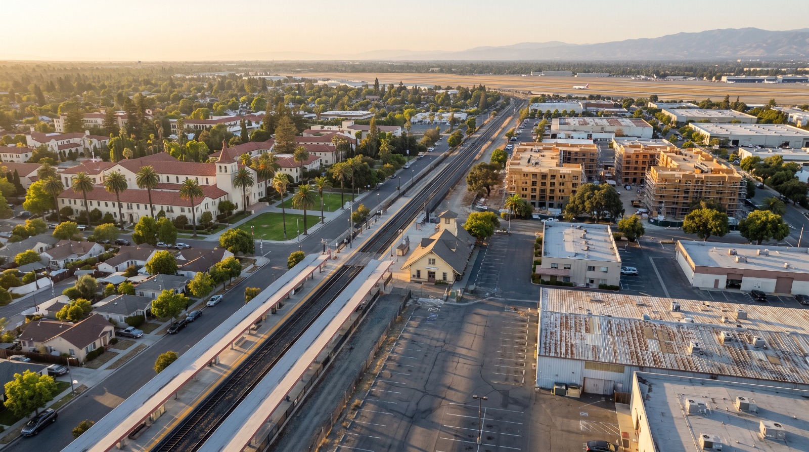
Aerial view of the Santa Clara Caltrain station area at golden hour, where the Station Area Specific Plan studies up to 8,300 homes Photo: Houseberry
On June 10, 2026, Santa Clara sent the state the biggest housing number it has ever attached to its Caltrain station: 8,300 homes. The filing is a Notice of Preparation for the Santa Clara Station Area Specific Plan, the first formal step in an environmental impact report, and it covers 244 acres on both sides of the tracks next to the Santa Clara Transit Center.
Alongside the homes, the plan would allow 2.1 million square feet of office, 1.7 million square feet of light industrial space and 19.5 acres of open space. Nothing here is approved. No Draft EIR has been published, and the City Council has not voted on a plan. The comment window on the notice ran June 12 to July 13 and is now closed.
My read, up front: this is the right place in Santa Clara for this much housing, and the number worth watching is whether 8,300 survives the airport, the EIR and the council.
Where the 244 acres are
The plan area runs from El Camino Real and Franklin Street on the southwest to De La Cruz Boulevard, Reed Street and Martin Avenue on the northeast, according to the notice. That puts it between the Old Quad, the historic grid of bungalows around Santa Clara University and the 1863 depot, and the warehouse and office blocks along Brokaw Road and Coleman Avenue that run up toward San Jose Mineta International Airport.
The state listing names 192 parcels, all in ZIP code 95050. Their current General Plan designations run the whole range, from Low Density Residential to Regional Commercial to Light Industrial. In plain terms, the plan area includes some existing homes, a lot of low-slung industrial land and the park-and-ride lot at El Camino and Benton Street where Caltrain riders leave their cars.
Santa Clara Station Area Specific Plan by the numbers
The notice is short on detail and long on square footage. Here is the full development program as filed, with the math that makes it readable.
| Use | Amount in the June 2026 notice | What it works out to |
|---|---|---|
| Homes | Up to 8,300 | About 34 per gross acre |
| Office | 2.1 million sq ft | Plan-wide total |
| Light industrial | 1.7 million sq ft | Plan-wide total |
| Retail | 134,920 sq ft | About 16 sq ft per new home |
| Institutional | 105,060 sq ft | Plan-wide total |
| Open space | 19.5 acres | About 8 percent of the plan area |
| Employees | About 10,500 | 539 commercial plus 10,000 industrial, per the state listing |
Thirty-four homes per acre sounds modest for a rail station, and it is misleading in a useful way. The 244 acres include streets, existing houses, the rail corridor and the open space, so the parcels that actually redevelop would run much denser than the average.
The retail figure is the one I would push on. About 16 square feet of shops per new home is thin for a neighborhood meant to be walked. A June letter in the Silicon Valley Voice made a similar case, arguing for restaurants and gathering places alongside the units.
The jobs math cuts the other way. Roughly 10,500 employees against 8,300 homes is close to balanced, which is unusual in Silicon Valley, where job growth has long outpaced housing.
8,300 is a ceiling, and it keeps going up
Every version of this plan has been bigger than the last. Santa Clara, San Jose and VTA finished an earlier Santa Clara Station Area Plan that was folded into the city's General Plan in November 2010. It covered about 440 acres in both cities and planned for 2,200 or more new homes.
When the current effort came to the Planning Commission on October 8, 2025, the preferred concept called for roughly 5,000 to 5,500 homes and about 2 million square feet of commercial space, according to a summary of the study session. Eight months later the environmental notice set the ceiling at 8,300.
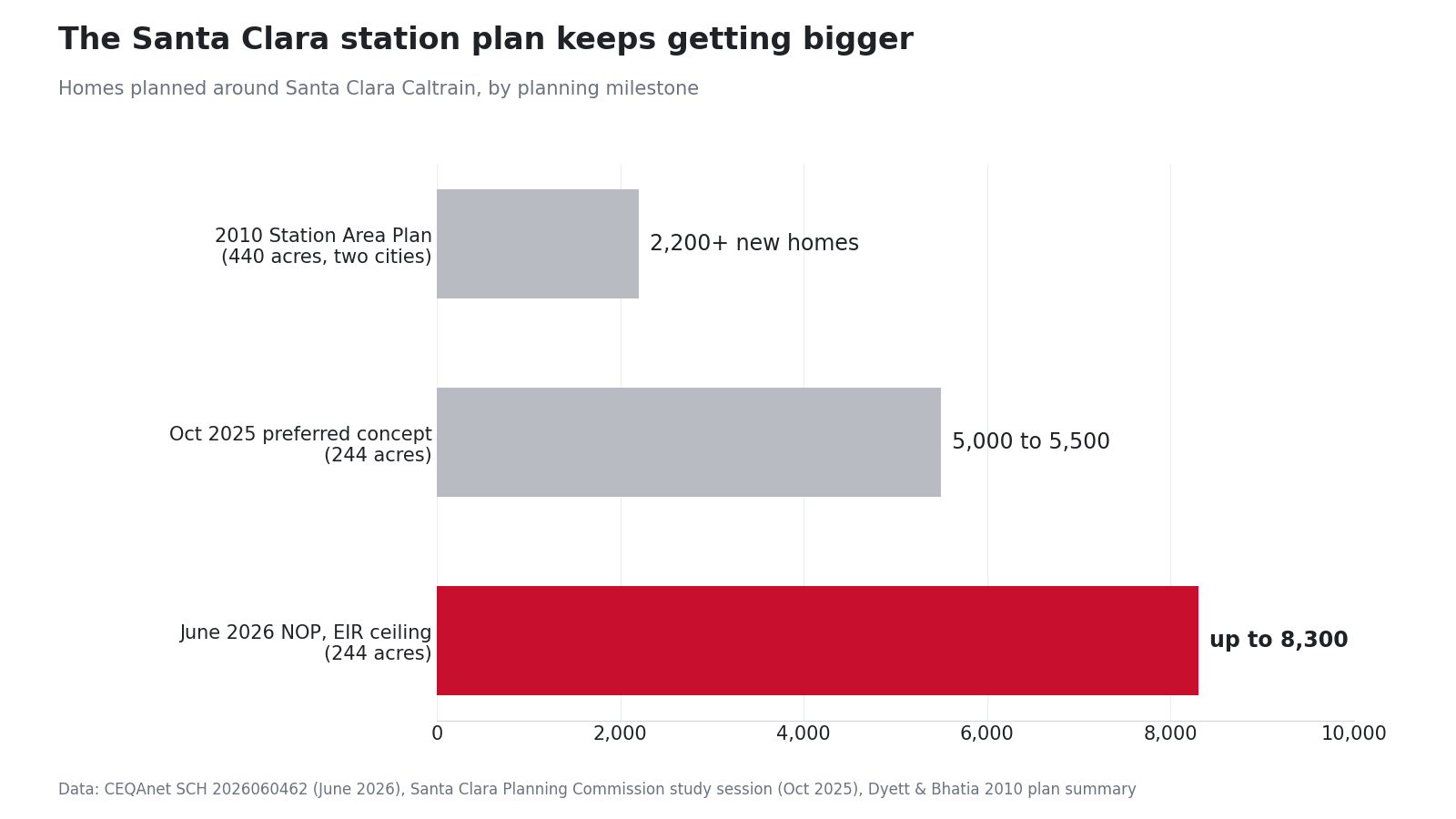
Treat that as an envelope, not a promise. Cities usually study the largest version of a plan in the EIR so they can adopt something smaller without redoing the analysis. The adopted plan could land at 8,300 or well below it.
But the direction matters. Santa Clara's state housing target for 2023 to 2031 is 11,632 homes. This one plan, at its ceiling, would cover about 71 percent of that number on land that is already next to a train.
How tall it could get, and why the airport decides
The airport, not the neighbors, will probably set the height limit. In its comment letter on the notice, Caltrans pointed out that the entire plan footprint falls inside the Santa Clara County Airport Influence Area, including safety zones and traffic pattern zones that limit height, density and noise exposure.
The heights the consultants floated are already modest. At a July 2025 Station Area Task Force meeting, the draft framework showed a base of about 85 feet, or seven floors, up to 13 floors near the station and the Brokaw corridor, about 40 feet where the plan meets existing houses, and 64 feet on light industrial parcels. Anything above the base would need FAA sign-off.
Here is the honest downside. Living here means jet noise on approach, freight trains on the Union Pacific line and a lot of construction for a long time. Planning commissioners in October also pressed staff on traffic along Coleman Avenue and on who pays for a proposed Benton or Brokaw crossing under or over the tracks. Fair questions, and the plan does not answer them yet.
What it means for the Old Quad and South 101
The plan area sits between two of the neighborhoods we score in Santa Clara, and both are mid-table or lower. Santa Clara East Central, the college-town grid around Santa Clara University and the Old Quad, scores 3.6 out of 5 overall and 4.0 for amenities, the best amenities score in the city. South 101, the mix of homes, tech campuses and big-box retail toward Reed Street and De La Cruz, scores 2.9, last of the seven.
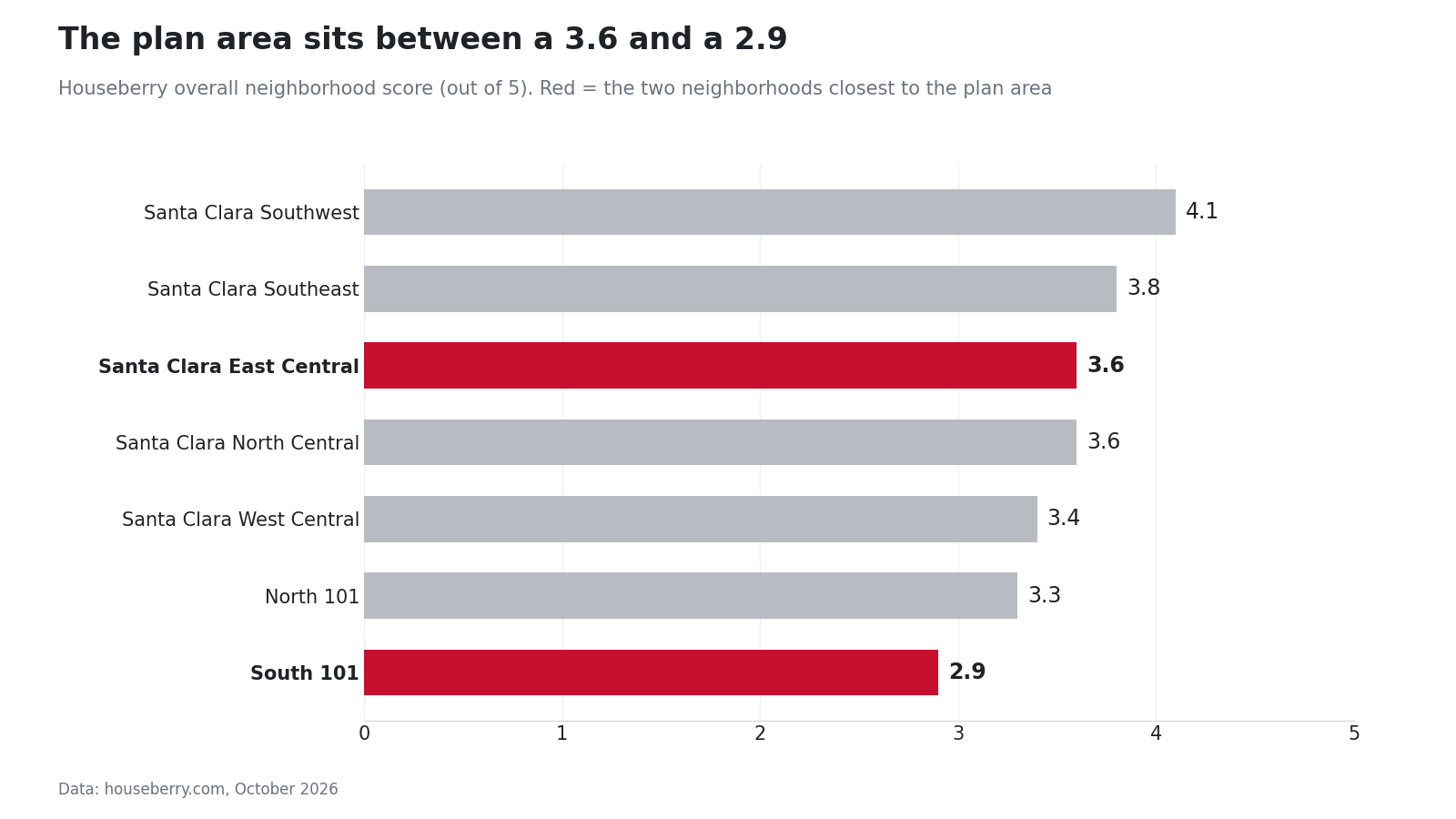
Prices tell the same story. Both sell below the citywide median, and North 101, across the freeway near Levi's Stadium, sits lower still.
| Neighborhood | Overall | Safety | Amenities | Median price |
|---|---|---|---|---|
| Santa Clara East Central | 3.6 | 3.6 | 4.0 | $1.67M (Sept 2026) |
| South 101 | 2.9 | 2.5 | 3.1 | $1.65M (Aug 2026) |
| North 101 | 3.3 | 2.8 | 3.5 | $1.43M (Sept 2026) |
| Santa Clara citywide | 3.5 | 3.4 | 3.5 | $1.86M (Aug 2026) |
The median sale price in Santa Clara East Central was about $1.67 million in September 2026, roughly 10 percent below the Santa Clara citywide median of about $1.86 million in August 2026. South 101 was about $1.65 million in August, and its 2.5 safety score is the lowest in the city, which is worth researching block by block rather than treating as a verdict.
For a buyer, the practical question is what 8,300 mostly multifamily homes do to neighborhoods like these. The way we look at it, a plan this size adds choices more than it threatens values. Today the entry point near the station is a $1.6 million bungalow. A finished plan would add condos, townhomes and apartments at the platform, and it would add the shops and parks that move an amenities score. The full Santa Clara neighborhood ranking is the place to compare the rest of the city.
Caltrain now, BART later
The transit case is real today. The Santa Clara Transit Center already runs Caltrain, ACE and VTA buses, and VTA lists BART Silicon Valley Phase II construction running from 2024 to 2036, ending at a ground-level Santa Clara station next to Caltrain. Anyone buying near here this decade should plan around Caltrain and treat BART as the bonus.
Pieces of the plan area are already moving. Our coverage of University Station, the 408 homes proposed across from the depot, was the first chapter. The city also approved 142 for-sale townhomes at 1400 Coleman Avenue) in November 2025, 29 of them affordable, and the staff report notes the site sits inside the station focus area. VTA still owns a 2.4-acre park-and-ride site at the station that it wants to redevelop with 25 percent affordable housing, though its last developer agreement expired.
This is also not the only big number in town. Santa Clara is separately moving to put 6,000 homes on 45 acres at Tasman East near Levi's Stadium.
Quick answers on the station plan
Is the Santa Clara Station Area Specific Plan approved?
No. As of October 1, 2026, the city has issued only a Notice of Preparation. A Draft EIR, a public draft of the plan, a Planning Commission recommendation and a City Council vote all still have to happen.
Will it rezone homes in the Old Quad?
Some existing residential parcels are inside the boundary, since the state listing includes Low and Medium Density Residential designations. The southwest edge is Franklin Street and El Camino Real. If you own near that edge, check whether your parcel number is among the 192 listed in the notice.
When will the Draft EIR come out?
The city has not posted a date. A May 2025 staff report targeted a public Draft EIR in spring 2026 and adoption hearings in summer 2026, and the notice itself arrived about a year behind that schedule. The regional grant funding the plan expires December 31, 2026.
The dates that decide it
The next moves come in a fixed order, and none of them is on a calendar yet.
- A public draft of the Specific Plan, with the height and street standards the task force has been working through.
- The Draft EIR, which opens a public comment period of at least 45 days.
- A Planning Commission hearing and recommendation.
- A City Council vote to adopt the plan and certify the EIR.
The scoping meeting was June 29 on Zoom, and senior planner Rebecca Bustos is the city contact listed on the filing. The city keeps a project page for the Station Area Specific Plan where the draft documents should appear.
Santa Clara planned for 2,200 homes here in 2010. This time the target is nearly four times larger, the state is pushing harder and BART is under construction. If the council keeps the number close to 8,300, the Old Quad gets a real neighborhood on the other side of the tracks. We will be reading the Draft EIR the day it posts, and Houseberry will update this piece when it does.
Sources
- CEQAnet, Santa Clara Station Area Specific Plan, SCH 2026060462
- City of Santa Clara, Notice of Preparation, June 2026
- Caltrans District 4, comment letter on the Notice of Preparation
- City of Santa Clara, Station Area Specific Plan project page
- City of Santa Clara, File 25-410, VTA cooperative agreement amendment, May 13, 2025
- City of Santa Clara, 1400 Coleman Avenue staff report, November 2025)
- CitizenPortal, Planning Commission study session summary, October 8, 2025
- CitizenPortal, Station Area Task Force summary, July 17, 2025
- Dyett and Bhatia, Santa Clara Station Area Plan (2010)
- VTA, BART Silicon Valley Phase II
- VTA, Santa Clara Transit Center transit-oriented development
- Silicon Valley Voice, letter on the Station Area Specific Plan, June 2026
- Silicon Valley Voice, Planning Commission recommends Housing Element update, January 2023
- Houseberry, Santa Clara neighborhood rankings and price history, October 2026
The Houseberry Research Team is Houseberry's reporting team: Bay Area real estate analysts, data specialists and longtime local market watchers. Every day we check the public record: building permits, city council and planning agendas, county recorder filings, state housing bills, police incident data and school results. Then we tie each story to what it means for specific neighborhoods, using Houseberry's own neighborhood data on prices, appreciation, safety, schools and amenities. Questions or corrections: Contact us.
Map of Santa Clara Neighborhoods
Loading map...
View Full Map
Top Neighborhoods in Santa Clara, CA



All information provided on this website including but not limited to - school ratings, safety, amenities, user opinions, and property data - is for general informational purposes only. We do not guarantee its reliability, accuracy, or completeness. Users should independently verify information and consult appropriate professionals as needed. By using this website, you agree Houseberry is not responsible for actions, decisions, or consequences arising from reliance on the information provided
houseberry.com - CA DRE# 01847391
 Bay East ©2025. CCAR ©2025. bridgeMLS ©2025. Information Deemed Reliable But Not Guaranteed. This information is being provided by the Bay East MLS, or CCAR MLS, or bridgeMLS. The listings presented here may or may not be listed by the Broker/Agent operating this website. This information is intended for the personal use of consumers and may not be used for any purpose other than to identify prospective properties consumers may be interested in purchasing. Data last updated at October 2, 2026 12:00 AM