Oakland's $3.6 billion storm drain bill lands on the flatlands
Oakland Public Works puts its storm drain bill at $3.63 billion, and a property-owner fee vote is no sooner than 2029. We mapped which Oakland neighborhoods sit in FEMA flood zones and listed what homeowners can check before El Niño storms arrive.

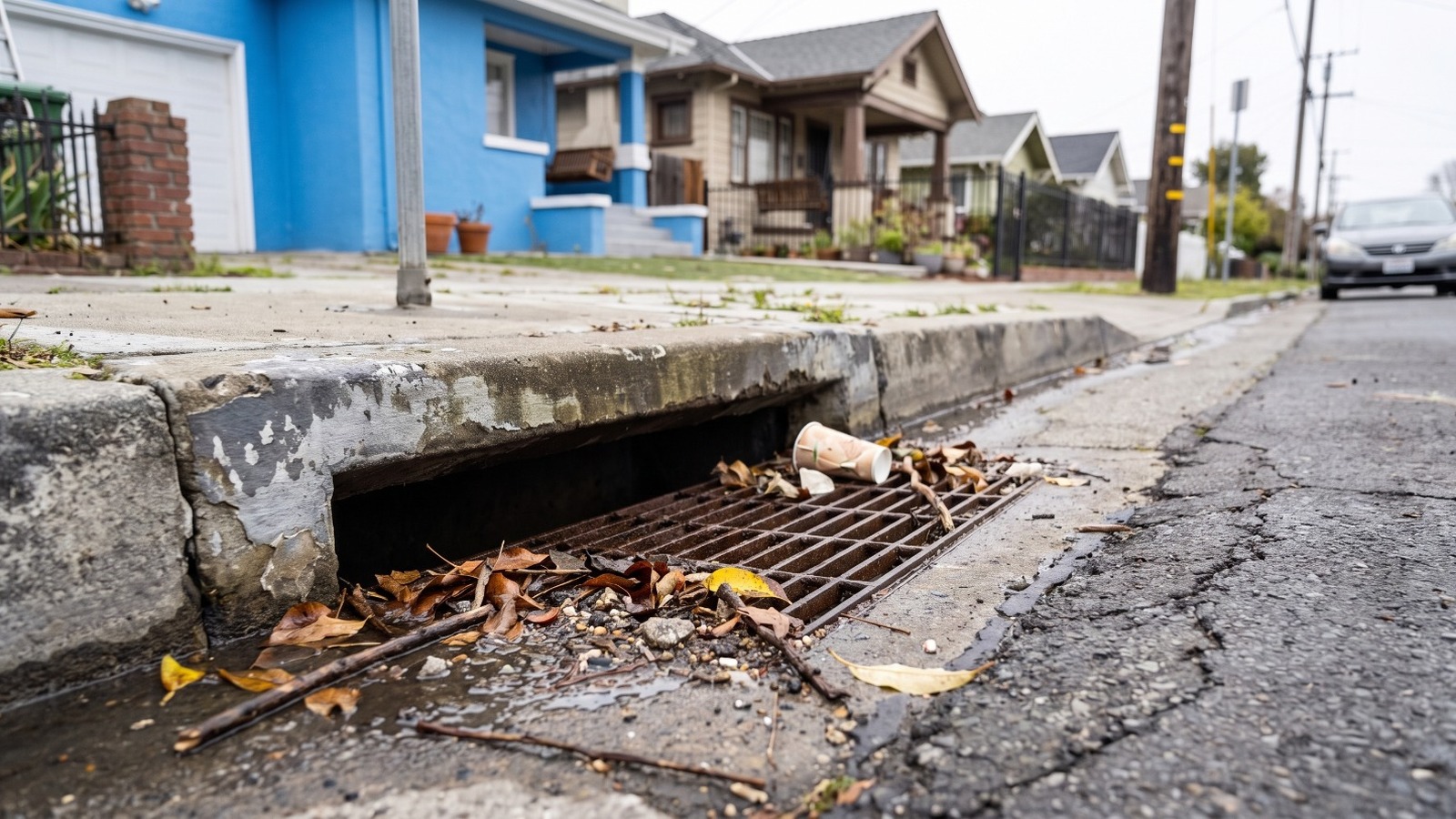
AI-rendered view of a leaf-clogged curbside storm drain on a residential block of 55th Avenue in East Oakland Photo: Houseberry
Oakland's storm drains need about $3.63 billion in repairs and replacement, and the city does not have the money. That estimate comes from an August 31 report by Oakland Public Works, which counts about 400 miles of pipe, 80 miles of creeks and channels, four pump stations and more than 18,000 inlets, culverts and other structures. Many of those pieces are over 85 years old.
The bill lands hardest on the flat half of the city. When we laid FEMA's flood maps over Houseberry's 130 Oakland neighborhoods, eight came out with more than half their land in FEMA's 0.2 percent flood zone, the band that floods in a rarer, bigger storm. All eight sit in the flatlands east of Lake Merritt, from Fruitvale toward the San Leandro line. Lenders do not require flood insurance there, and most homeowner policies do not cover flooding.
This winter could be the stress test. The Climate Prediction Center's October 8 update keeps an El Niño Advisory in place and puts the odds of a strong to very strong event through early 2027 above 83 percent. A wet California winter is more likely in a year like that. It is not guaranteed.
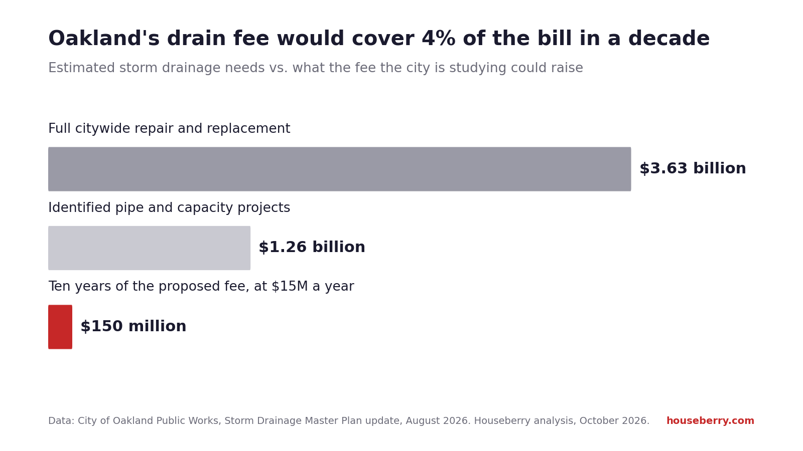
A $3.63 billion bill and a fee that covers a sliver
The report went to the City Council's Public Works and Transportation Committee on September 22, where members received and filed it. Nothing was approved. Public Works Director Liam Garland signed it. Terri Fashing, who runs the city's watershed and stormwater division, prepared it. The Storm Drainage Master Plan behind it started in 2020 and is about 75 percent done, with a final version due in 2027.
The yearly numbers show the gap. Keeping the current system cleaned and inspected the right way would take about $16.3 million a year, and meeting state water quality rules at least $24 million more. Against that, the fee the city is studying would raise $10 million to $15 million a year. Berkeley's version, approved in 2018, costs a typical single-family home $42 a year. Alameda's, from 2019, is $78.
Do the division and it gets stark. At $15 million a year, the fee alone would need about 240 years to raise $3.63 billion. Fashing told The Mercury News that the $1.26 billion project list would take 30 to 50 years even with funding, and that 30 to 40 percent of the system needs rehabilitation or replacement. Bonds and state and federal grants would have to carry most of the load, the report says.
The report's own warning about doing nothing is blunt. Repairs get pricier, failures get more frequent, and the city takes on more legal liability for flooding. We have seen what one failure looks like. On January 1, 2023, the culvert carrying Arroyo Viejo Creek under the Oakland Zoo's entrance road on Golf Links Road collapsed and left a sinkhole about 10 feet deep. The zoo stayed closed for weeks.
Where FEMA's map puts the water in Oakland
Houseberry's flood overlay, built from FEMA's National Flood Hazard Layer and our neighborhood boundaries this month, shows the 1 percent zone in Oakland is mostly the airport and the shoreline. The 0.2 percent zone is a different story. It spreads across whole residential flatland neighborhoods along the creeks that run down from the hills.
| Neighborhood | Land in FEMA 0.2% zone | Land in FEMA 1% zone | Houseberry overall score | Safety score |
|---|---|---|---|---|
| Fitchburg | 98.4% | 0.8% | 1.6 | 1.6 |
| Fruitvale Station | 68.3% | 0.0% | 1.7 | 1.2 |
| Sausal Creek | 67.0% | 3.4% | 2.7 | 3.6 |
| Coliseum Industrial | 63.9% | 3.9% | 1.4 | 1.3 |
| Woodland | 57.4% | 0.0% | 2.0 | 2.1 |
| Arroyo Viejo | 56.0% | 3.0% | 2.0 | 2.2 |
| St. Elizabeth | 54.3% | 6.5% | 2.2 | 2.4 |
| Melrose | 54.2% | 0.0% | 2.0 | 1.9 |
Shares are Houseberry analysis of FEMA flood maps, October 2026. Scores are from the Houseberry Oakland ranking, out of 5.
The pattern holds beyond the top eight. Twenty-one Oakland neighborhoods have at least a fifth of their land in one of FEMA's two zones, and their median Houseberry overall score is 2.0 out of 5. The 74 neighborhoods with under 1 percent have a median of 2.5. None of the city's 30 top-ranked neighborhoods reaches the 20 percent mark. That lines up with the city report, which says flooding has historically fallen on the flatlands the city ranks highest for equity needs.
Sausal Creek is the outlier in the table. It ranks 46th of 130 on Houseberry's list and carries a 3.6 safety score, the best of the eight, yet two-thirds of its land sits in the 0.2 percent zone along the lower creek.
Prices here run a little over half the city's. Houseberry's price history puts the typical home in Woodland at about $545,000 in September 2026, Arroyo Viejo at about $502,000 and St. Elizabeth at about $503,000. The Oakland citywide figure was about $927,000. The other neighborhoods in the table had September figures that jumped or stayed frozen for a year, so we left them out.
FEMA's map has a blind spot. It shows creeks and the bay rising, not a clogged inlet backing up onto a street. The city's own map of reported flooding hot spots, dated March 6, 2026 and attached to the report, scatters dots from the Oakland hills to the San Leandro line. A hillside address outside every FEMA zone can still flood at the curb.
Why we would put the fee on the ballot anyway
At $42 to $78 a year in the two neighboring cities, about $3.50 to $6.50 a month, a fee like this is the right thing to put in front of Oakland property owners. We would vote for it. It is a down payment. The honest catch is the one in the chart above: even passed, it fixes a fraction of the system, and every year without it the repair list gets longer and more expensive.
What an Oakland homeowner can check before the rain
- Look up the address on FEMA's Flood Map Service Center.
- Ask your insurance agent whether your policy covers flood. Most homeowner policies do not, and federal flood policies usually take 30 days to start.
- Clear the inlet nearest your driveway of leaves before each storm. The city's Adopt-a-Drain program covers more than 13,000 drains and lends volunteers tools.
- Report a spot that floods every winter on the city's Storm Drainage Master Plan page, which has a hot spot form in English, Spanish and Chinese. For urgent street flooding or a broken pipe, dial 311 in Oakland or 510-615-5566.
- When heavy rain is forecast, Public Works hands out up to 10 sandbags and 20 feet of plastic sheeting with ID at 7101 Edgewater Drive and at 5921 Shepherd Canyon Road. Hours are on the city's extreme weather page.
Our earlier look at flood zones across Bay Area neighborhoods covers the regional picture.
The ballot that could start fixing Oakland's pipes is at least two more winters away, and this one is forecast to be among the strongest El Niño winters since 1950. Before the first big storm, check your block on FEMA's map and see how your part of the flatlands scores on Houseberry's Oakland neighborhood ranking.
Sources
- City of Oakland, Storm Drainage Master Plan Update and Stormwater Fee Report, August 31, 2026 (File 26-0860)
- City of Oakland, Reported Flooding Hotspots Map, March 6, 2026 (Attachment B)
- The Mercury News, Oakland's aging storm drains need $3.6 billion in repairs, October 8, 2026
- NOAA Climate Prediction Center, ENSO diagnostic discussion, October 8, 2026
- Oakland Zoo, extended closure due to sinkhole, January 2023
- City of Oakland, Adopt-A-Drain
- FEMA Flood Map Service Center
The Houseberry Research Team is Houseberry's reporting team: Bay Area real estate analysts, data specialists and longtime local market watchers. Every day we check the public record: building permits, city council and planning agendas, county recorder filings, state housing bills, police incident data and school results. Then we tie each story to what it means for specific neighborhoods, using Houseberry's own neighborhood data on prices, appreciation, safety, schools and amenities. Questions or corrections: Contact us.
Map of Oakland Neighborhoods
Loading map...
View Full Map
Top Neighborhoods in Oakland, CA




All information provided on this website including but not limited to - school ratings, safety, amenities, user opinions, and property data - is for general informational purposes only. We do not guarantee its reliability, accuracy, or completeness. Users should independently verify information and consult appropriate professionals as needed. By using this website, you agree Houseberry is not responsible for actions, decisions, or consequences arising from reliance on the information provided
houseberry.com - CA DRE# 01847391
 Bay East ©2025. CCAR ©2025. bridgeMLS ©2025. Information Deemed Reliable But Not Guaranteed. This information is being provided by the Bay East MLS, or CCAR MLS, or bridgeMLS. The listings presented here may or may not be listed by the Broker/Agent operating this website. This information is intended for the personal use of consumers and may not be used for any purpose other than to identify prospective properties consumers may be interested in purchasing. Data last updated at October 11, 2026 12:00 AM